


'Traffic Congestion' As Solvable, Part 2
Turning to Junctions, scraping back layers of pseudo-science.

In part 1, we obtained a shared understanding of counting how many vehicles could fit in a lane at a given speed.
Buckle up. This edition is image-heavy. Since I’m mostly talking about that form of ethnic cleansing originating in America, this post will focus on American intersections. This framework will make intuitive sense to normal people, but ‘traffic planners’ might stress because I make zero references to the shibboleths of their domain.1
This publication is overall oriented towards expanding the ‘imagination problem-space’ for how vehicles, and the space allocated to them, and the people who pilot them, move (and do not move) in the varieties of spaces available to them throughout earth.
If one travels by car from one point (say, the street in front of a house) to another point (say, a grocery store, or place of employment) one will invariably encounter three distinct phenomena related to road networks:
traveling down ‘simple’ lane segments (discussed here)
traveling across/around/through the space consumed by junctions, where one lane segment interacts with another lane segment. (Prototypically, think: stop lights, stop signs, roundabouts, and ‘uncontrolled’ intersections)
vehicle storage, be it parallel parking on a street, parking it in a parking lot, or parking it in a garage
I believe these three points cover most of the human experience as related to using a car.
I’ll eventually talk about all three of these. #1 is already discussed, #2 is what we’re discussing today in this piece you’re currently reading, and maybe one more edition, and then #3 will come after that.
Last time, we did lots of analysis of the River North district in Denver, so we’ll keep doing the same.
First, we’re going to talk about junctions as consuming/using a certain square footage that is knowable, and then we’ll do a brief foray into graphing movement speeds.
1. Defining Junctions As `Consuming A Knowable, Defined Space`
How to define a junction?
A mix of form and function, obviously. Some aspects of junctions are obvious, some are subtle.
We’ll start with defining the geometry of a shape of a ‘base case’ junction:

The purple blob is the geometry I’m mentally allocating to this junction. Google Maps reports the polygon to be 194 sq ft.
You’ll note that the cross walks are not included (because crosswalks are for carless drivers) and I’m also avoiding the space used by the bike lanes, because this is a car junction, and overall cars should not infringe on the space allocated to bicycles.
This is a two-way stop. Notice the white lines on the ground, on the north and south sides of the intersection? Notice that there are no white lines on the lanes coming from the east or west?
This means the cars from the east/west don’t need to stop, or even slow down, but the cars passing north/south need to take special actions to ensure they don’t hit from either direction. I have Opinions on this configuration.
Next, a junction controlled by traffic lights, with a slip lane:

This sort of intersection will soon be seen to multiply harm and misery upon the world.
This 287 sq ft polygon is the most generous, space-effective form of characterizing this junction.
As you’ll soon see, the smaller the junction the better, because we’ll be coming up with a metric like “vehicles moved per minute, per meter”, and an intersection that has twice the square meters but only 20% extra vehicles per minute performs objectively worse on this standardized evaluation.
Here’s how I might re-draw that polygon if I was feeling ungenerous:

There’s a case to be made for this being the correct interpretation of the geometry of this intersection/junction. The above greenish polygon is 540 sq feet.
Here’s a 200 sq foot polygon. No intersection markings or affordances in either direction:

I found a roundabout!

This polygon is 215 feet:

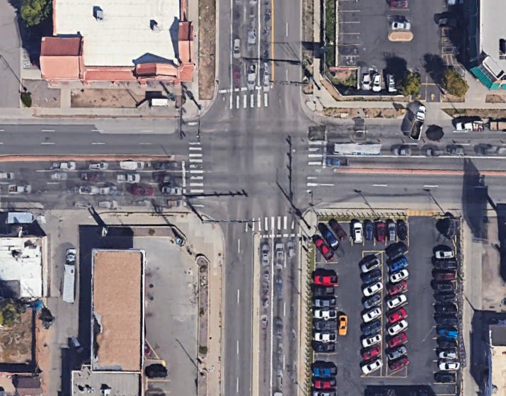
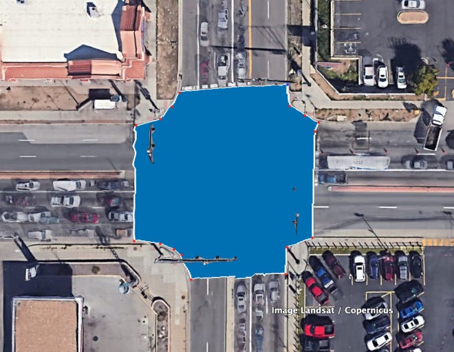
Here’s another intersection, it’s got… a lot going on:

I don’t like signs, paints, instructions, or rules. Healthy environments give affordances to the expected activities, and the users of the space flow in and out of it in a complicated, chaotic, coordinated dance. There’s a million examples of how things could be (outside the USA) and I’ll get some of those explained soon enough. For now, though, how would you characterize this intersection? What portion of it would you say is the right ‘shape’ of the polygon that would define the intersection?
Here’s my attempt. It’s 190 sq ft, oh, and this is a ‘four-way signalized intersection”:

Lets jump classes of intersections. Here is one of hundreds of intersections on Colefax:

How big will the polygon be?

Option 1 is 205 sq feet. I’m tempted to loop in the cross walks, because when the light is red, this is all space consumed by the ‘junction’, regardless of it there are people in it or not. It certainly isn’t space that could be considered ‘lane feet’ for calculating the carrying capacity of a road. This is 280 sq ft.

Lets look at a larger intersection, also on Colefax:

How would you draw that polygon? Here’s how I would do it:

That’s 1000 sq feet. A lot of lanes. This is a ‘big’ intersection/junction. It’s also extremely dangerous, and people die here all the time. If you’re attuned to these kinds of things, simply looking at this intersection reveals the risky nature of it.
If you’re not yet attuned to these things, keep reading.
Finally, here’s a standard intersection between two stroads. This is the worst-case intersection that is built in America today, and sows sadness and harm and danger on everyone who touches it, interacts with it, and avoids it.
How would you draw the shape, and what do you anticipate the dimension will be?
There’s no slip lanes, but it’s 2/3 lanes each direction, plus a turning lane.
423 sq ft:
Such for imagining the shape of a given junction.
Next, lets discuss how junctions are used. Presumably, vehicles flow through them at a certain rate.
2. Junctions as Enabling Movement and Enforcing Stoppage
My own verbiage causes me a little bit of cringe. I hope to fix some of this before publishing it.
Junctions (at their best/fulfillment of their purpose) enable certain paths of movement, and, in some situations, enforce/require ‘stoppage’. Definitionally, a signalized intersection functions only by permitting some movement (green light) while stopping other movement. (red light).
A stop sign enforces some stoppage, as most people stop or almost stop when passing through a stop sign.
An ‘uncontrolled’ intersection encourages something like slowing and cautiousness and a little complex decision making before the users move through it.
Here is where we first encounter a challenge of this medium I’m using. I’m pressing buttons on this little metal box over here, and, eventually, due to 🪄, you’ll be reading it on your own little metal and glass box. These words that I write are intrinsically static. Nothing moves. A better software-person than myself would have already created the cool Javascript-based animations to illustrate (and allow you to play with the parameters) how a given object might move through a space with various speeds, stopping, and starting. Or multiple objects.
Alas, here we are. So, I’m going to try to convey to you with words and static images something already fundamentally true. Something that you intuitively know to be true, and experience, perhaps 100 times a day.
When going somewhere, your trip contains moments of movement, and moments of stillness. One could graph a single transition from movement to stillness and back to movement like this:

Your speed is non-zero at the beginning, and as time moves forward, it drops to zero, stays there for a time, then rises from non-zero.
Assuming everything stayed the same, we might agree that the trip segment defined by this graph would be superior:

Overall, constant movement punctuated by a quick dip to zero, and then a return to movement.
Let’s graph a longer imaginary trip. See if you can pick up what I’m layin’ down. If you can smell what I’m stepping in:

Movement at a speed, then slowing down, then a brief stop, then back to speed, then back to a stop, remaining stationary, then moving again.
We could imagine a trip through city streets with stop signs and stop lights to look like this:

The grand conclusion that I want to land, the point of this entire second section of this already enormous missive, is that the following curve would be superior to the above curve, on several levels:

If the speed never goes to zero… well, now, that’s an interesting hypothetical to entertain and contains paradigm-shifting implications.
Lastly, I want to land that two different junction designs might promote two different movement patterns:
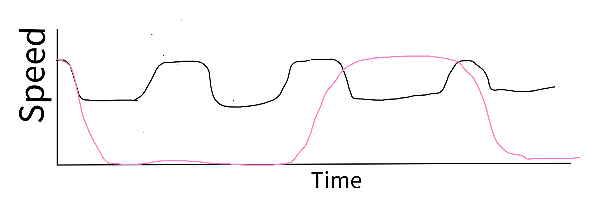
Can you intuit the difference? Black might be… right turns in an area without stop signs/stop lights, or moving through an area without traffic lights.
Pink is certainly traffic lights, keeping one stopped for a long time.
3. Combine the dimension of an intersection with the movement pattern/speed of its usage
Combining the two above points of this article, we’re closer to arriving at the point I want to land about junctions. The first is that junctions contain real space, so, to the degree that we make decisions and affordances to anything else in the physical world that consumes space, we can do the same with junctions.
Next, vehicle movement patterns contain periods of faster movement, slower movement, and moments of being stationary. Most of the stationary-ness imposed by junctions is in the waiting for ‘permission’ to use the junction, rather than the movement pattern once inside the junction.
Next time, we’ll cover the ‘the shape of the flow’ through an intersection. Turbulent vs. smooth. Dangerous vs. safe. Complicated vs. simple. Convivial vs. Dominant.
We will also evaluate some real life junctions. I’ve got a little drone footage floating around showing vehicle throughput for junctions, and I’ll probably collect more.
We’re moving towards a position where we can say “this junction moves X vehicles per Y minutes per square meter”.
When we get there… holy hell. It’s common to experience as noteworthy anytime an exponential function overlays a banal, conventional part of life. We’re gonna get there.

-❤️, Josh
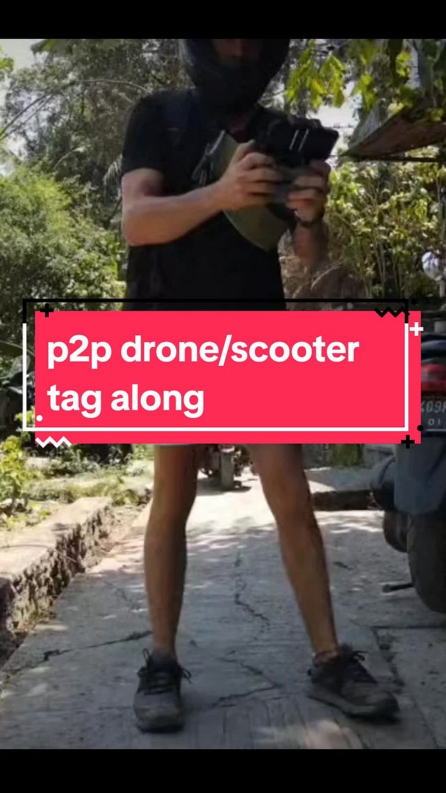
PS As a bonus for getting to the bottom, here’s a real-world depiction of the concepts I’m working on illustrating in these few posts. It’s a tiktok drone video I got a few weeks ago, if the embed isn’t working, here’s a direct link:
 Tiktok failed to load.
Enable 3rd party cookies or use another browser
You’ll note a mix of ‘space consumed per vehicle’, ‘space consumed while moving’, and trip progress relative to max speed, low speed, and being stationary. You’ll also see a few different intersection types and usage patterns around said intersections.
If any traffic planner would feel more emotional safety if I connected my points to one of their shibboleths, please let me know, I’ll consider it.