


Traffic Congestion as Solvable, Part 3: Intro to Path Shaping
Cars take space, at rest and when moving, and intersections take space, and can be used by more or less people at once, especially when some thought is given to the paths various can use.

In part 1, we said something like “a car takes up at least 20 feet of space when stationary, and it consumes incrementally more square feet per second as it approaches a speed of, say, 60mph/90kph”.
In part 2, I proposed that:
one can look at a road segment, and draw a line around the portion of the asphalt contained within that junction, and can then know something like “how many square meters of space that intersection consumes”, and standing aside it for a few minutes can quickly get a ‘vehicles moved per square meter, per minute”
We next can appreciate that, when traveling around by car, a trip could have many times that a vehicle is stationary, or no times that a vehicle is stationary, and broadly the latter option would be preferable to the former, and it could be exemplified on a graph with certain shapes and labels.”
For part 3, I’m going to make legible to you some of the obvious and predictably and watchable patterns regularly visible on a road segment visible outside my window.

Doesn’t it look boring?
Have you heard the phrase “the map is not the territory”? Lets make the obvious upgrade to our vision:

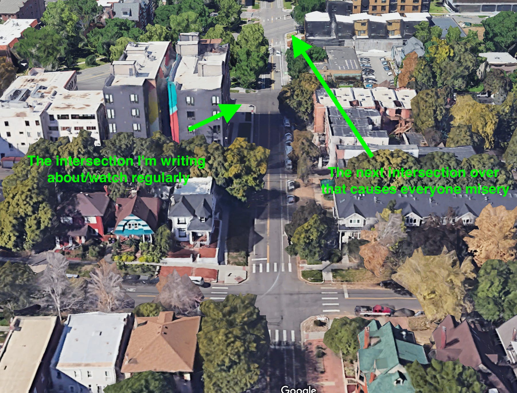
The green shape is the intersection we’re discussing.
It doesn’t matter the actual address, because this exact pattern, and ‘primitives’ of the pattern exist in 10,000 places in Denver and wherever there is an incorporated municipality within the USA.
To use the language of the kinds of people who invented jaywalking [that is, reluctantly], this blobby shape incompasses:
one intersection is signalized/controlled, another is a four-way stop
there are some alleys, dedicated bike lanes, and pedestrian affordances like painted crosswalks
There’s a few apartment buildings with a combined total of hundreds of people within the blocks bordering/facing the blobby shape. This sort of ‘density’ is relatively rare within Denver.
One of the intersections, in the parlance of traffic engineers, is ‘an uncontrolled intersection’. There can be “four-way uncontrolled intersections” or “two-way uncontrolled intersections”, roughly, and this uncontrolled intersection has stop signs on the north and south side, but not for east or west-bound traffic.1
As these obvious and predictable patterns become legible, two things will happen:
You might/hopefully will derive some ancillary benefit around being able to more sensitively attune to some aspect of using these types of roads, on wheels or on your feet, making it incrementally more likely that you’ll safely navigate from A to B. 2
You’ll be more aware of a particularly common and dangerous ‘design pattern’ in American cities, all of which share common features with “ethnic cleansing”, which all included the same kit of road expansion design standards. Some of the places that ethnic cleansing happened, this pattern exists. Where this pattern exists, ethnic cleansing happened, some of the time. When someone says “wow this is dangerous and unpleasant” now you can say “that is precisely correct, here is why that’s the case, and here’s why that was a desired outcome for the people that built it.”
If you ever find yourself interacting with some formal entity around something related to roads (police, city engineers, planning officials, homeowners)\ you’ll perhaps feel less exasperated and a bit more savvy.
Author’s note: This has been a hard post to write. It started as another generalized post, but since part 2, which by now was written months ago, I moved into a lovely/good-enough studio apartment in Denver. A lot has changed/settled, often in very nice ways. There’s lots to like about it. The building has a roof-top deck with a view, and from a window, I can overlook several intersections, and of course I interact with these intersections many times daily. Sometimes walking, sometimes scooting, sometimes driving. Sometimes alone, sometimes with my daughter, sometime with friends. I’m visited by friends and family who walk, scoot, bike, and drive. I feel intensely things about the upsides and downsides of Denver’s current mobility network. I want to write smaller and simpler posts, for everyone’s sake, but if I don’t write it now, it gets harder and harder to ever write it!
In the parlance of American Traffic Planning, when thinking about this road, they would say
it’s three intersections, all are four way intersections, with a complete street infrastructure upgrade on some of it, one intersection is controlled by a light, one is uncontrolled, and one controlled by a four-way stop.
Both are fantastically dangerous intersections that violate the sensibilities of regular people, and indicate criminal negligence and mismanagement. That’s banal and barely worth mentioning, though, because the fact that roads and intersections led directly to the deaths of tens of thousands was never considered an issue by the Highway Men in America, because the people doing the dying were the people of the global majority, not the politically powerful white men. Anyway…
Where I live, where I just moved into a few weeks ago, I’m overlooking a road junction. It’s an intersection that features many times during some hours extremely dangerous dynamics, partially because of “adjacent intersections”.
This entire collection of intersections could be rendered completely safe for every single user, permanently, in all conditions, regardless of “enforcement” or “driver’s desire to comply”, tomorrow.
We would use curves to set max speed3, and we would use shapes to cause conditions for the gentle interleving of traffic of all modes. Bollard-type things to separate space for cars from space for all others, and to separate directions of travel from each other, and to create pedestrian ‘islands’. All of these are fancy ways of something that could be as simple as placing not-small rocks on the road in a certain pattern.
I could draw out the intersection, but I’ll just screenshot it:
If you look at the bare overhead satellite image, can you see the dynamics? Park ave, the five-lane-wide diagonal-cutting street, cuts 16th (going up/down) which also cuts Humboldt, going left/right.
An incredible amount of space is given to moving cars around, compared to space for people, and this intersection features dangerous interactions continuously.

Here’s a little more explanation:
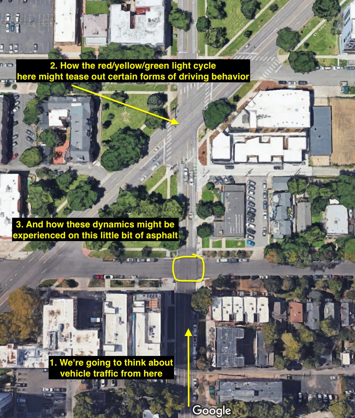
OK, talk me through what you would expect to see, if you were to sit near this intersection and watch it for a while. What would you see during a morning rush hour? What would you see at 11p? In the snow?
Here’s some of where my mind naturally goes, when thinking about this intersection, again all the dynamics pertaining to someone driving ‘north’, in a car, either going straight or turning either direction

I’ve been doing distance and speed measuring (more on that later) and how much space do you think a car might consume across two seconds when a driver is trying to catch that light?
140 feet, easily. (That’s how far a car travels in 2 seconds at 50 mph. I’ve witnessed faster movement than that.)
For a not-rushing person traveling by foot, they might take three seconds to cross a single lane of traffic. There’s also a community of elderly people on the same block as me, and they obviously move a bit slower than a fast-walking adult. Watching someone push a walker across the street causes me active stress.
Obviously someone driving at 50 mph expects foot traffic to perceive them and not get in the way.
It’s screamingly obvious that some car drivers going through the intersection believe it’s the walking person’s job to avoid the car, rather than the other way around. They treat this street as a controlled-access highway, which is exactly what the road designers intended, so it’s not precisely anyone’s “fault” today, though I do continue to hold road engineers responsible and in contempt for knowing better and failing to do better.4 It’s obvious that they think ‘jaywalking’ is a real thing that reasonable people ‘should’ not do.
Fixing The Intersection
There’s probably a future where I take orange construction cones to the intersection for data gathering, and I’ll write about it.5
The last time I did this, in Loveland, the local police came out and demanded that I “stop threatening harm against car drivers by expecting them to be able to pilot their own vehicles in a responsible-enough fashion to avoid rear-ending each other as various drivers eased off the accelerator” in response to a handful of plastic traffic cones I put out. The police obviously think very poorly of the motoring public, perhaps justifiably. I still maintain the correctness of what I’m advocating for.
For that saga, you’ll have to check my tiktok. Part 1, Part n, part n+1, part n+2, the actual plan for ‘shaping’ the intersection (it’s not actually changing the shape, it’s marking an optimistic geometry of intended travel), sourcing the cones, ground-level view of the intersection, how it looks with a few cones out, quick thoughts right after the local Public Works authority freaked out and ratted me out to the local police force, who showed up to make credible threats of violence against me. “I could get you for stealing public property” the patrol said to me, staring at the cones I moved 150 meters. Obviously police know they ‘control’ the local roads, and it is as obvious that they’re not really sure why.
Everything I want to do to this intersection would briefly increase the complexity it faces. By increasing some complexity, one can decrease another kind of complexity. It’s all exactly the point. And for a time, things would look a bit messier. this is all expected and part of the process, evidence that something is working.
Please note that this is temporary, and there’s a very interesting talk about improving the design of software systems that says very clearly “to make something better, it necessarily goes through a period of interstitial increase in complexity/messyness. It’s okay.” (Sandi Metz talk, “Guilded Rose”)
This is an approximate shape informed by having done a lot of this kind of thing before.
The following design would work well if the intersection was sliiiightly larger, I think. Here’s what I first conceptualized:

The lines represent shapes that could be made with paint, for starters, and then outlined with posts, like some sort of bollard, stone, metal, whatever. Bollards should be used in a way to create the shape but to leave space for people. I wrote a tribute to Bollards, and a criticism of american traffic planners.
The intersection outlined above is large enough for left-turning vehicles to easily round the center point, but here’s another, perhaps easier starting point. Start by simply making little ‘pedestrian islands’, in the middle of each lane.

You can see the shape - if these little narrow diamonds were made out of something, crashworthy or not, but visible and protruding up from the ground, cars passing through the intersection would have to drift just a smidge to the outside, even if passing straight, and then back.
That bend would cause at minimum the average driver to ease of the accelerator.
They would also create little islands and zones of confidence for people walking across the road. If they were bollards, they would create actual safety for the people, rather than just confidence.
Here’s the tiktok of a before, and an after, this sort of treatment. All of these sorts of videos show how you can use cones to ‘shape’ vehicle paths, and to ‘squeeze’ the path, which causes a natural attentiveness to the driving. It becomes clear that vehicle speed vehicle path of travel is quite associated.
It’s definitionally not possible to “take certain curves above certain speeds”. People who try have what we call ‘accidents’, and if those accidents are constrained by bollards, no one can be injured but the driver who failed to pilot their vehicle adequately. It’s fitting and just.
Here’s an example:
https://twitter.com/HB8710/status/1634629736499486721
This pattern of speed-shaping-via-curves, done two or three times in a row, in replacement of stop lights and stop signs, sets expectations for drivers. There’s no need to rush, because being 3 seconds late won’t ever cost you 2 minutes of waiting and you’re in a rush.
Obviously the curves don’t have to relate to the road changing direction, like in the above video, it can be in a road that travels in an otherwise straight line.
So, sure, someone might still technically be able to go as fast as they want, especially if they’re willing to run over cones (some emotionally immature people drive over the cones intentionally, obviously, of course. That’s why I support bollards.)
“But josshhhhhh this is America, we cannot live like this!”
I know all too well of what you speak. Lets make it worse. Here’s how I’d fix park, by ‘necking down’ all of the travel lanes into a single lane each direction, and ‘giving that space back’ to the people. Rip up all the asphalt, replace it with trees and native grasses and benches and eventually street car lines.

Basically, my pattern would be “eliminate all traffic lights, stop signs, and uncontrolled intersections, to be replaced with small traffic circles or otherwise flowy junctions”. There would be less light pollution (from red/yellow/green lights), noise pollution (from accellerating/racing/breaking car drivers) less tailpipe pollution, less rubber microplastic pollution, less visual pollution, and the intersection would be dramatically safer for all users.
If any road is currently more than one lane in any direction, neck it down to a single lane each direction.
Every junction, be it a road to alley, or a sidewalk to road, or a road and a road, deserves treatment.
At minimum, in each direction of travel, one side of the intersection will be marked with a center post, ideally a bollard. This tiny affordance alone would cause an enormous increase in safety in the entire affected area, and peacefulness, less noise, less racing, etc.
That Park and Colefax are currently FIVE LANES WIDE, each, is an abomination.
“But Josh where would the cars fit if there’s not enough laaaaaaaaanes.”
What I hear is either:
“But Josh, I have legitimate questions about urban mobility network vehicle space utilization while vehicles are in motion.” (or something like that. I’ll answer these)
“But Josh, I unselfconciously spout pseudo-scientific propaganda.” (I am less enthusiastic to perceive and accommodate you.)
We’ll talk about Linear Parks later, but what you’re seeing is the beginning of what ‘should’ be done to wide roads. I don’t actually see it as that complex of a problem, besides the political authority bit.
The road I’m focusing on so hard was once a pedestrianized boulevard, during Covid, and I’d like to make it so again. There used to be streetcar lines on three different sides of this block, within 100 meters:
When I think of “white american’s norms for how cities should look and function” I think of that painting by Goya, Saturn Devouring His Son:

It’s tragic. The rampant unsafety injected into cities by creating these huge unrestricted channels for cars, and the norms and socializing that happens around cars and how vehicles are piloted through space, is insane.
I have a friend that was walking down a street side-by-side with her fiance, when a passing vehicle was struck by another passing vehicle. One of the vehicles was being driven responsibly, the other was being driven irresponsibly. As a result of the collision, one of the vehicles “bounced” onto the sidewalk and killed her. It also knocked her fiance into a coma, and he woke up days later only to find that, of course, his fiance was dead. Bollards would have preserved their lives, and the well-being of their family, and the expense of tens of thousands of dollars and the years of harm and sadness for dozens of people this event caused.
In at least some ways, an American traffic planner might suffer harm if they say anything but both “oops”, and “that was unpreventable”. There’s a concept elsewhere that says when an institution refuses to “feel shame” over a real harm, it forces onto the victim that shame. That’s how that ‘energy’ gets released. That shame might not be received, but that’s still the direction that energy goes. “I didn’t do anything bad, you are bad and thus you deserve it”, in this place goes: “The intersection/design isn’t bad, it’s the bad person who was using it and did it to themselves”.
Soooooo yeah I care. 🤷
Back to intersection dynamics.
Here’s a few seconds of a portion of the area in consideration:
Here’s the graphic, the camera is from the point of view from the bottom of the image, looking “up”:
I cannot figure out the right way to visualize the flow of people and cars around these intersections, that best/most eligantly lands the point for you, the reader, that I want to land.
Traffic lights cause people to stop, and the number of ‘waiting minutes’ climbs quickly at an intersection. A rightly-shaped traffic circle causes a ‘first in, first out’ queuing cycle, rather than a light, which might say ‘last in, first out’ depending on when you get the light cycle.
Lights also cause the intersection to be empty, regularly, waiting for the light cycle to switch from one direction to another. Imagine the smooth flow of a traffic circle - constant use, as long as there is a vehicle waiting to pass through, and the traffic flows in the order in which it arrives, and no direction is given dominance over another direction - traffic circles support right straight and left as much as they do going right.
The most dangerous dynamics to encounter when taking turns in a car usually center around left turns or crossing dangerous/fast roads. Especially when trying to time lights one direction or both.
I feel deep, daily anger over this.
I cannot avoid mentally swapping the words “uncontrolled intersection” with “known dangerous, routinely inadequate, unpleasant for everyone, supportive of genuinely dangerous conditions, especially in the routine rhythms of our environment, like day and night, rain, snow, moisture, cold. “Uncontrolled intersection” is propaganda, to take the phrase seriously is to give up all power for improvement. Intersections don’t need to be controlled but they need to be thoughtfully-enough designed, or at least certain harmful influences need to not be injected.
Especially if you are from another country and visiting america, if you’re driving or walking, this can serve as a useful guide to trying to stay a little more safe. American road norms have openly, known-dangerous patterns built in from the get-go, and American vehicles tend to be large, boxy, and have horrible sightlines and visibility. I’ve got drafted a piece dedicated just to the phenomena of tinted windows, and how much danger it creates, by removing the ability to see if a vehicle operator even has their head pointed in my general direction as I’m making sure they don’t pull in front of me or whatever.
Here’s what it looks like to define a curve, and what it looks like to exceed a speed threshold, and how to use bollards to show the curve and retain boundaries, to the protection of other users of the space: https://twitter.com/WorldBollard/status/1634871668077371392
To witness dangerous or harmful dynamics and say/do nothing, or to resist the actions taken by others to improve the situation, on the other hand, is bad/contemptible.
marking the middle points of the lanes in both directions, and marking the edges of the bike lane, would cause a nice speed reduction, on average, just by encouraging drivers to ease off the gas as they pass through the intersection.